Gaya at a Glance
Country: India
State:Bihar
Administrative division: Magadh
Tehsils: 880
Sex ratio:932 females for every 1000 males. Population growth rate:
Population growth rate over the decade 2001-2011 was 26.08%. Literacy rate:
Literacy rate of Gaya is 66.35%.
Area: 4,976 km2 (1,921 sq mi)
Population (2011): 4,379,383
Density: 880/km2 (2,300/sq mi)
Major highways:NH 2, NH 82, NH 83 Temperature:
Minimum 0.8 (2002 AD) degree C Maximum 49.8 (1996) degree C Rivers:
Falgu Blocks in gaya:
Gaya Sadar, Manpur, Bodh Gaya, Wazirganj, Belaganj; Khizarsarai, Atri, Nimchakbathani, Muhra; Sherghati, Amas, Mohanpur, Fatehpur, Barachatti, Imamganj, Dumaria, Bankey Bazar, Dobhi, Tankuppa, Gurua, Guraru, Paraiya, Tekari, Konch, Sub Divisions in Gaya:
•Gaya Sadar
•Neemchak Bathani
•Sherghati
•Tekari
एक नज़र में गया
क्षेत्र: 4, 9 76 किमी 2 (1,921 वर्ग मील)
जनसंख्या (2011): 4,37 9, 383
घनत्व: 880 / किमी 2 (2,300 / वर्ग मील)
प्रमुख राजमार्ग:एनएच 2, एनएच 82, एनएच 83 तापमान:
न्यूनतम 0.8 (2002 एडी) डिग्री सेल्सियस अधिकतम 49.8 (1 99 6) डिग्री सेल्सियस
नदियाँ:Falgu
क्षेत्र: 4, 9 76 किमी 2 (1,921 वर्ग मील)
जनसंख्या (2011): 4,37 9, 383
घनत्व: 880 / किमी 2 (2,300 / वर्ग मील)
प्रमुख राजमार्ग:एनएच 2, एनएच 82, एनएच 83 तापमान:
न्यूनतम 0.8 (2002 एडी) डिग्री सेल्सियस अधिकतम 49.8 (1 99 6) डिग्री सेल्सियस
नदियाँ:Falgu
गया में ब्लॉक:गया सदर, मनपुर, बोध गया, वजीरगंज, बेलगंज; खजसारसाई, अट्री, निमचकबथानी, मुहर; शेरघाटी, अमास, मोहनपुर, फतेहपुर, बाराचट्टी, इमामगंज, दुमरिया, बंकी बाजार, दोभी, टैंकुपा, गुरुुआ, गुरुरू, परैया, तेकरी, कोच, गया में उप-विभाजन:
• गया सदर
• नीमचक बाथानी
• Sherghati
• Tekari
history
 Gaya finds mention in the great epics, Ramayana and Mahabharata. Rama along with Sita and Lakshmana visited Gaya for offering PIND-DAAN to their father Dasharath. In Mahabharata, the place has been identified as Gayapuri. About the origin of the name ‘Gaya’ as referred to in Vayu Purana is that Gaya was the name of a demon (Asura) whose body was pious after he performed rigid penance and secured blessings from Vishnu. It was said that the Gayasura’s body would continue to be known as Gaya Kshetra.
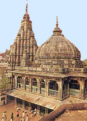
Gaya has experienced the rise and fall of many dynasties in the Magadh Region. From the 6th century BC to the 18th century AD, about 2300–2400 years, Gaya has been occupying an important place in the cultural history of the region. It opened up with the Sisunaga dynasty founded by Sisunaga, who exercised power over Patna and Gaya around 600 BC. Bimbisara, fifth in line, who lived and ruled around 519 BC, had projected Gaya to the outer world. Having attained an important place in the history of civilisation, the area experienced the bliss of Gautam Buddha and Bhagwan Mahavir during the reign of Bimbisara. After a short spell of Nanda dynasty, Gaya and the entire Magadha region came under the Mauryan rule with Ashoka (272 BC – 232 BC) embracing Buddhism. He visited Gaya and built the first temple at Bodh Gaya to commemorate Prince Gautama’s attainment of supreme enlightenment.
The period of Hindu revivalism commenced with the coming of the Guptas during the 4th and 5th century A.D. Samudragupta of Magadh helped to bring Gaya in limelight. It was the headquarters of Behar district during the Gupta empire.Gaya then passed on to the Pala Empire with Gopala as the ruler. It is believed that the present temple of Bodh Gaya was built during the reign of Dharmapala, son of Gopala.
Gaya was in the 12th century invaded by Muhammad Bakhtiyar Khilji. But the Hindu rulers defeated his generals later. The place finally passed on to the Britishers after the battle of Buxar in 1764. Gaya, along with other parts of the country, won freedom in 1947.
Gaya formed a part of the district of Behar and Ramgarh till 1864. It was given the status of independent district in 1865. Subsequently, in May 1981, Magadh Division was created by the Bihar State Government with the districts of Gaya, Nawada, Aurangabad and Jehanabad. All these districts were at the level of sub-division when the Gaya district was created in 1865.Gaya has seen three districts partitioned off from its territory: Aurangabad and Nawada in 1976 and Jehanabad in 1988.
It is currently a part of the Red Corridor.
Economy:

In 2006 the Ministry of Panchayati Raj named Gaya one of the country’s 250 most backward districts (out of a total of 640).[5] It is one of the 36 districts in Bihar currently receiving funds from the Backward Regions Grant Fund Programme.
Education:
 There are a number of schools in Gaya District, most of them are very popular and provide better education as compared with other cities, names are as follows, Zila School, Gaya, Mahavir School, Town School, T Model School, Gaya High School, Hadi Hashmi High School, Qasmi High School, Agrawal high school, Belaganj are some of the schools being run under the Bihar School Examination Board in Gaya for quite long time.
Kendriya Vidyalaya, Nazareth Academy, Gyan Bharti, Creane Memorial School, DAV Rotary Campus and DAV Cannt Area. Many new schools have come up in recent time and these are: St. Ann’s School, Jai Hind Public School, Shatabdi Public School, Spring Dales, Green field and, High School (Kormathu), High School (Paibigha). +2 High School (Paraiya), +2 Ashok High School (Paraiya), High School Bala Bigha, M. S. Bala Bigha, Elegant Public School,
Gaya is one of the thirty-eight districts of Bihar state, India. It was officially established on 3 October 1865. The district has a common boundary with the state of Jharkhand to the south. Gaya city is both the district headquarters and the second-largest city in Bihar.